Fishtail

Annapurna Basecamp Trek

Trip Facts

The area known as the Sanctuary of Annapurna was a treasured and sacred spiritual refuge long before the first trekkers arrived.

A natural amphitheatre, ringed by Annapurna South, Annapurna I, Varahashikhar, Gangapurna and the holy Fishtail Mountain (Macchapucchre), the Sanctuary was adopted as the Annapurna South Base Camp by the successful British summit expedition in 1970.

The Sanctuary is a three-mile by five-mile pocket of three glaciers, encircled by nine icy summits. The tiny valley floor rarely receives more than seven hours of sunlight, even on a clear day, because of the barrier effect of the peaks.

The first few days of this trek are spent travelling through quaint villages and luxuriant forest, before reaching more barren, more rugged terrain.

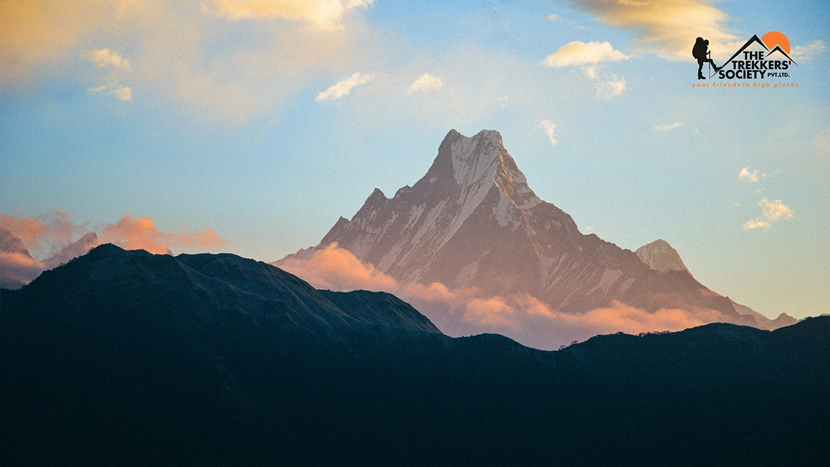
From Chomrong, the last village of the valley, the twin peaks of Macchapuchre are clearly visible, looking exactly like a fishtail.

Bamboo is a major theme of the next part of the trek, which moves on upwards through the gorge. The mats on the walls and floors of the lodges, the dokos carried by the porters, the forest you are walking through : all is bamboo.

Next the landscape gives way to grey scree and scrub before reaching snow-fields as you apporach the sanctuary. Entering this you walk between rocky ribs, which descend sharply from either side. The most common sight to greet you is the fog of swirling clouds.

From Base Camp there are some tremendous views: a labyrinth of mountains which tower almost vertically above, with Annapurna I dominant.

An hour or two is spent here taking in the high mountains before commencing the return journey to Pokhara, which takes five more days.

The Annapurna Base Camp itinerary is a good introduction to trekking at higher altitudes, without being too strenuous.

Highlights

  • Spectacular views from Annapurna Base Camp with glacier and mountain.
  • Views of Dhaulagiri, Himchuli, Mt Fishtail and Annapurna I
Itinerary
Trip PlanExpand all
Max Altitude: 1,320 m. / 4,330 ft. Meals: Breakfast, Lunch, DinnerMode of Travel: Bus

Transfer to hotel and rest.

Max Altitude: 1,320 m. / 4,330 ft. Meals: Breakfast, Lunch, Dinner

visit major UNESCO heritage sites and trek briefing.

Max Altitude: 1,960 m / 6,430 ft Meals: Breakfast, Lunch, DinnerMode of Travel: Flight + JeepDrive Hours: 2.5 - 3 Hrs.Distance: 827 Kms.

Fly from Kathmandu to Pokhara, then drive to Ulleri.

Max Altitude: 2,860 m / 9,385 ft Meals: Breakfast, Lunch, DinnerMode of Travel: On Foot ( Trek)Drive Hours: 5-6 Hrs.Distance: 10 Kms.

Trek from Ulleri to Ghorepani. Trek time about 5–6 hours through rhododendron forests and mountain villages.

Max Altitude: 2,300 m / 7,545 ft Meals: Breakfast, Lunch, DinnerDrive Hours: 6 - 7 Hrs.Distance: 10 Kms.

Early morning hike to Poon Hill (3,210 m / 10,531 ft) for sunrise views, return to Ghorepani, then trek to Chuile. Total walking 6–7 hours.

Max Altitude: 2,360 m / 7,742 ft Meals: Breakfast, Lunch, DinnerMode of Travel: On Foot (Trek)Drive Hours: 6 - 7 Hrs.Distance: 10 Kms.

Trek from Chuile to Sinuwa. Trekking about 6–7 hours through lush forests and small settlements.

Max Altitude: 3,200 m / 10,498 ft Meals: Breakfast, Lunch, DinnerMode of Travel: On Foot (Trek)Drive Hours: 6 Hrs.Distance: 12 Kms.

Trek from Sinuwa to Deurali or Himalaya. Trekking around 6 hours along the Modi River valley.

Max Altitude: 4,130 m / 13,550 ft Meals: Breakfast, Lunch, DinnerMode of Travel: On Foot (Trek)Drive Hours: 6 - 7 Hrs.Distance: 8 Kms.

Trek from Deurali to Annapurna Base Camp via Machhapuchhre Base Camp. Trekking about 6–7 hours. Overnight at ABC surrounded by Himalayan peaks.


Max Altitude: 2,310 m / 7,579 ft Meals: Breakfast, Lunch, DinnerMode of Travel: On Foot (Trek)Drive Hours: 6 - 7 Hrs.Distance: 15 Kms.

Trek from Annapurna Base Camp down to Bamboo. Descend for about 6–7 hours

Max Altitude: 1,780 m / 5,839 ft Meals: Breakfast, Lunch, DinnerMode of Travel: On Foot (Trek)Drive Hours: 5 - 6 Hrs.Distance: 10 KMs.

Trek from Bamboo to Jhinu Danda. Enjoy the natural hot springs near the Modi River. Walking 5–6 hours.

Max Altitude: 2,100 m / 6,889 ft Meals: Breakfast, Lunch, DinnerMode of Travel: On Foot (Trek)Drive Hours: 5 Hrs.Distance: 5 Kms.

Trek from Jhinu to Pitam Deurali. Trek time around 5 hours.

Max Altitude: 827 m / 2,713 ft Meals: Breakfast, Lunch, DinnerMode of Travel: On Foot (Trek)Drive Hours: 3 - 4 Hrs.Distance: 6 Kms. + 25 Kms.

Trek from Pitam Deurali to Kande (1,770 m / 5,807 ft) and drive back to Pokhara. Trek 3–4 hours and drive about 1.5 hours.

Max Altitude: 1,320 m. / 4,330 ft. Meals: Breakfast, Lunch, DinnerMode of Travel: FlightDrive Hours: 25 Mins.Distance: 200 Kms.

Pokhara Sightseeing – visit Davis Falls, Gupteshwor Cave, Bindabasini Temple, and Phewa Lake boating. Afternoon fly back to Kathmandu.

Meals: Breakfast

Departure after Breakfast.

Still Confuse?
Download brochure or customize your trip.
Customize Trip
Did not find what you are looking for? Let’s talk!
Need Help? Call Us.+977 9851087278